National Loop Walks
Druid’s Loop Walk (6 kilometres, 1hr 15mins)
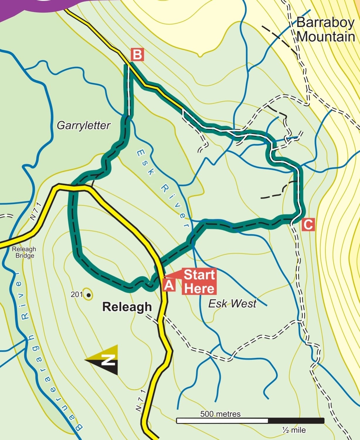
A-B. From the trailhead follow the green (and blue and purple) arrows through the gate and onto the farm laneway. The blue and purple arrows are for longer loops. Embark on a delightful journey through a traditional Irish farmyard. Follow the laneway as it ascends to the top of the hill behind the farm. The path then descends, crosses the main road, and continues down a farm roadway until you reach an iron bridge over Esk Stream. Cross the bridge, turn right, and follow the laneway to connect with a surfaced road.
About 7,000 years ago, Ireland was thickly forested across most of the entire country – even highland areas were forested. During the Neolithic Age, the first farmers began to clear the trees and establish farms and settlements. As the climate became wetter, the soil of these tree-less areas became more acidic. Heathers, rushes, and other plants grew in this soil but their debris did not completely decompose in water-logged areas and a layer of peat began to build up.
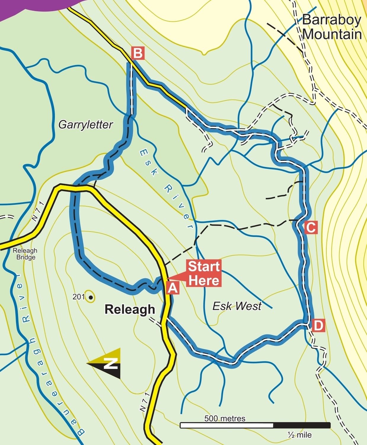
Fionn mac Cumhaill Loop walk (6 kilometres, 1hr 30mins)
A-B: From the trailhead, follow the blue, green, and purple arrows through the gate and onto the farm laneway. The green arrows indicate a shorter loop, while the purple arrows mark a longer loop. Enjoy your journey through the traditional Irish farmyard as the laneway ascends to the top of the hill behind the farm. The loop then descends, crosses the main road, and continues along a farm roadway until you reach an iron bridge over Esk Stream. Cross the bridge, turn right, and follow the laneway to join a surfaced roadway. All three loops turn right here.
B-C: Now, the loops join with the Beara Way – a long-distance walking route around the Beara Peninsula, marked with familiar yellow arrows and a walking man symbol. At the second Y-junction, the Beara Way and the purple loop turn left, but you continue straight. Follow the roadway for over 1 km and watch for a large hayshed on your right. The green loop turns right through a gateway here, but you continue straight ahead.
C-D: Continue to follow the blue arrows along the roadway, passing several junctions until you reach a right bend where a roadway to your left leads to the Crows Nest. The purple loop rejoins here. Veer right.
D-A: Follow the sand road for 500 meters to cross Esk Stream at a concrete bridge and continue for another 500 meters to a T-junction with the MAIN ROAD. Turn right and be aware of traffic for the last 200 meters back to the trailhead.
Cailleach Beara Loop Walk (12 kilometres, 4-5 hours)
Gear: Hiking boots, raingear, fluid, snack, and mobile phone. Terrain: Laneways, woodland tracks, cross country, hillside.
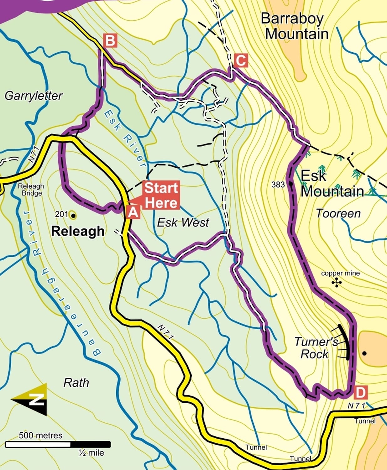
A-B: From the trailhead, follow the blue, green, and purple arrows through the gate and onto the farm laneway. The green arrows indicate a shorter loop, while the purple arrows mark a longer loop. Enjoy the journey through the traditional Irish farmyard as the laneway ascends to the top of the hill behind the farm. The loop then descends, crosses the main road, and continues along a farm roadway until you reach an iron bridge over Esk Stream. Cross the bridge, turn right, and follow the laneway to join a surfaced roadway. All three loops turn right here.
B-C: Now, the loops join with the Beara Way—a long-distance walking route around the Beara Peninsula, marked with familiar yellow arrows and a walking man symbol. At the second Y-junction, the Beara Way and the purple loop turn left, but you continue straight. Follow the roadway for over 1 km and watch for a large hayshed on your right. The green loop turns right through a gateway here, but you continue straight ahead.
C-D: Continue to follow the blue arrows along the roadway, passing several junctions until you reach a right bend where a roadway to your left leads to the Crows Nest. The purple loop rejoins here. Veer right.
D-A: Follow the sand road for 500 meters to cross Esk Stream at a concrete bridge and continue for another 500 meters to a T-junction with the MAIN ROAD. Turn right and be aware of traffic for the last 200 meters back to the trailhead.
